
Mapa topográfico Indian Lake
Mapa interativo
Clique no mapa para exibir a altitude.
Indian Lake
Indian Lake has the fourth-highest elevation of towns in Pennsylvania, at 2281 feet. This is the Lake water level, homes at Indian Lake range from 2300 to 2550 feet in base elevation.
Sobre este mapa
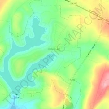
Nome: Mapa topográfico Indian Lake, altitude, relevo.
Local: Indian Lake, Somerset County, Pennsylvania, United States (40.02331 -78.88721 40.06545 -78.83897)
Altitude média: 732 m
Altitude mínima: 679 m
Altitude máxima: 817 m