
Faça uma doação
Mapa topográfico Mount Ainslie
Clique no mapa para exibir a altitude.
Faça uma doação
Mount Ainslie
Mount Ainslie is a hill with an elevation of 843 metres (2,766 ft) AHD that is located in the northeastern suburbs of Canberra, in the Australian Capital Territory, Australia. Mount Ainslie lies within part of the Canberra Nature Park.
Faça uma doação
Sobre este mapa
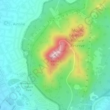
Nome: Mapa topográfico Mount Ainslie, altitude, relevo.
Altitude média: 649 m
Altitude mínima: 572 m
Altitude máxima: 839 m
Faça uma doação
Outros mapas topográficos
Clique em um mapa para visualizar sua topografia, sua altitude e seu relevo.
Lake Burley Griffin
Charles Robert Scrivener (1855–1923) recommended the site for Canberra in 1909, which was to be a planned capital city for the country. One of the reasons for the location's selection was its ability to store water "for ornamental purposes at reasonable cost"; Scrivener's work had demonstrated that the…
Altitude média: 589 m
Faça uma doação
Faça uma doação