
Mapa topográfico Ashburton
Mapa interativo
Clique no mapa para exibir a altitude.
Sobre este mapa
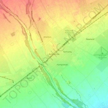
Nome: Mapa topográfico Ashburton, altitude, relevo.
Altitude média: 99 m
Altitude mínima: 67 m
Altitude máxima: 132 m
On the whole, Ashburton shares a similar climate to Christchurch i.e. a dry temperate climate (Cfb). However, since it lies further inland at a higher altitude to Christchurch, Ashburton experiences a greater range of temperatures. During summer Ashburton can exceed 30 °C (86 °F), whilst winter can see regular frosts and annual snowfall. Ashburton's heaviest snowfall was 38 centimetres (15 in) on 12 June 2006, conversely it is tied with Timaru for New Zealand's fourth-highest temperature on record, reaching 41.3 °C (106.3 °F) on 7 February 1973.
Outros mapas topográficos
Clique em um mapa para visualizar sua topografia, sua altitude e seu relevo.
Ōtūroto / Lake Heron
New Zealand > Canterbury > Ashburton District
Ōtūroto / Lake Heron, Ashburton District, Canterbury, New Zealand
Altitude média: 750 m
Totara Peak
New Zealand > Canterbury > Ashburton District
Totara Peak, Ashburton District, Canterbury, New Zealand
Altitude média: 1.645 m
Rakaia Gorge lookout
New Zealand > Canterbury > Ashburton District
Rakaia Gorge lookout, Arundel Rakaia Gorge Road, Ashburton District, Canterbury, New Zealand
Altitude média: 358 m
Dromore
New Zealand > Canterbury > Ashburton District
Dromore, Ashburton District, Canterbury, 7772, New Zealand
Altitude média: 123 m
Methven
New Zealand > Canterbury > Ashburton District
Methven, Ashburton District, Canterbury, 7730, New Zealand
Altitude média: 322 m
Hackthorne
New Zealand > Canterbury > Ashburton District
Hackthorne, Ashburton District, Canterbury, New Zealand
Altitude média: 199 m
Mayfield
New Zealand > Canterbury > Ashburton District
Mayfield, Ashburton District, Canterbury, 7778, New Zealand
Altitude média: 266 m
Ashburton Lakes
New Zealand > Canterbury > Ashburton District
Ashburton Lakes, Ashburton District, Canterbury, New Zealand
Altitude média: 645 m
Ruapuna
New Zealand > Canterbury > Ashburton District
Ruapuna, Ashburton District, Canterbury, New Zealand
Altitude média: 302 m
Mount Somers
New Zealand > Canterbury > Ashburton District
Mount Somers, Ashburton District, Canterbury, New Zealand
Altitude média: 1.221 m
Lake Clearwater
New Zealand > Canterbury > Ashburton District
Lake Clearwater, Ashburton District, Canterbury, New Zealand
Altitude média: 751 m