
Mapa topográfico Saint Lawrence County
Mapa interativo
Clique no mapa para exibir a altitude.
Sobre este mapa
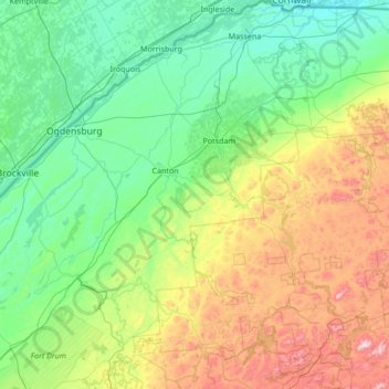
Nome: Mapa topográfico Saint Lawrence County, altitude, relevo.
Local: Saint Lawrence County, New York, United States of America (44.05040 -75.86164 45.01586 -74.52526)
Altitude média: 239 m
Altitude mínima: 44 m
Altitude máxima: 929 m
Outros mapas topográficos
Clique em um mapa para visualizar sua topografia, sua altitude e seu relevo.
Manhattan
United States of America > New York > Manhattan Community Board 5
Manhattan, Manhattan Community Board 5, New York, New York County, New York, United States of America
Altitude média: 17 m
Ithaca
United States of America > New York > Ithaca
Ithaca, Ithaca Town, Tompkins County, New York, United States of America
Altitude média: 194 m
Queens County
United States of America > New York > New York
Queens County, New York, United States of America
Altitude média: 11 m
New York County
United States of America > New York > New York
Manhattan, New York County, New York, United States of America
Altitude média: 17 m