
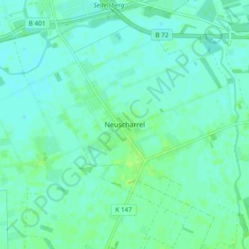
Mapa topográfico Neuscharrel
Mapa interativo
Clique no mapa para exibir a altitude.
Sobre este mapa
Nome: Mapa topográfico Neuscharrel, altitude, relevo.
Altitude média: 8 m
Altitude mínima: 4 m
Altitude máxima: 14 m
Ahrensdorf | Altenoythe | Augustendorf | Edewechterdamm | Ellerbrock | Friesoythe | Gehlenberg | Heinfelde | Kampe | Kamperfehn | Markhausen | Mehrenkamp | Neuscharrel | Neuvrees | Pehmertange | Schlingshöhe | Schwaneburg | Schwaneburgermoor | Thüle
Outros mapas topográficos
Clique em um mapa para visualizar sua topografia, sua altitude e seu relevo.
Edewechterdamm
Deutschland > Niedersachsen > Landkreis Cloppenburg > Friesoythe
Edewechterdamm, Friesoythe, Landkreis Cloppenburg, Niedersachsen, Deutschland
Altitude média: 7 m
Pirgo
Deutschland > Niedersachsen > Landkreis Cloppenburg > Friesoythe > Altenoythe
Pirgo, Altenoythe, Friesoythe, Landkreis Cloppenburg, Niedersachsen, 26169, Deutschland
Altitude média: 8 m
Mittelsten Thüle
Deutschland > Niedersachsen > Landkreis Cloppenburg > Friesoythe > Mittelsten Thüle
Mittelsten Thüle, Friesoythe, Landkreis Cloppenburg, Niedersachsen, 26169, Deutschland
Altitude média: 18 m
Neuvrees
Deutschland > Niedersachsen > Landkreis Cloppenburg > Friesoythe > Neuvrees
Neuvrees, Friesoythe, Landkreis Cloppenburg, Niedersachsen, 26169, Deutschland
Altitude média: 14 m
Altenoythe
Deutschland > Niedersachsen > Landkreis Cloppenburg > Friesoythe > Altenoythe
Altenoythe, Friesoythe, Landkreis Cloppenburg, Niedersachsen, 26169, Deutschland
Altitude média: 9 m