
Mapa topográfico Millau
Mapa interativo
Clique no mapa para exibir a altitude.
Sobre este mapa
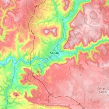
Nome: Mapa topográfico Millau, altitude, relevo.
Local: Millau, Aveyron, Occitania, Metropolitan France, 12100, France (44.01667 2.99064 44.17985 3.24486)
Altitude média: 656 m
Altitude mínima: 331 m
Altitude máxima: 895 m
The territory of this town lies across a southern portion of the Massif Central. It covers a large area of some 16,823 hectares (41,570 acres), which makes it the 25th largest metropolitan town in France. The municipality lies at the heart of the Grands Causses, a part of the Causse Rouge (east of the plateau Lévézou), and part of Larzac as well as part of the Black Causse. The city county seat is located in the lower part of the town, in a large depression at the confluence of the Tarn and Dourbie, at an altitude of about 340 m.
Outros mapas topográficos
Clique em um mapa para visualizar sua topografia, sua altitude e seu relevo.
Le Dourdou de Conques
Le Dourdou de Conques, Aveyron, Occitania, Metropolitan France, France
Altitude média: 576 m