
Mapa topográfico Hickory
Mapa interativo
Clique no mapa para exibir a altitude.
Sobre este mapa
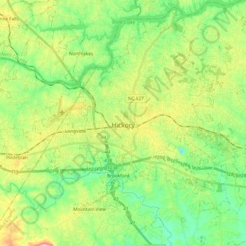
Nome: Mapa topográfico Hickory, altitude, relevo.
Local: Hickory, Catawba County, North Carolina, United States (35.66124 -81.40356 35.80737 -81.23537)
Altitude média: 317 m
Altitude mínima: 218 m
Altitude máxima: 512 m
Lake Hickory was named after the City of Hickory and runs along its northern edge. The lake covers almost 4,223 acres (17.09 km2) with 105 miles (169 km) of shoreline. Full pond elevation is 935 feet (285 m). Lake Hickory is a reliable source of water for the Cities of Hickory and Conover and the Town of Long View, while also functioning as a recreation hub for boating, fishing, and other water based activities.
Outros mapas topográficos
Clique em um mapa para visualizar sua topografia, sua altitude e seu relevo.
Newton
United States > North Carolina > Catawba County
Newton, Catawba County, North Carolina, 28658, United States
Altitude média: 287 m