
Faça uma doação
Mapa topográfico Mundelein
Clique no mapa para exibir a altitude.
Faça uma doação
Mundelein
Mundelein is located 33 miles (53 km) northwest of the Chicago Loop. The area of the village is 10.12 square miles (26.2 km2), 0.45 square miles (1.2 km2) of which is water. The elevation of the village is 742 feet (226 m). Mundelein borders Hawthorn Woods and Vernon Hills to the south and east, and is primarily located within the Indian Creek watershed in Lake County.
Faça uma doação
Sobre este mapa
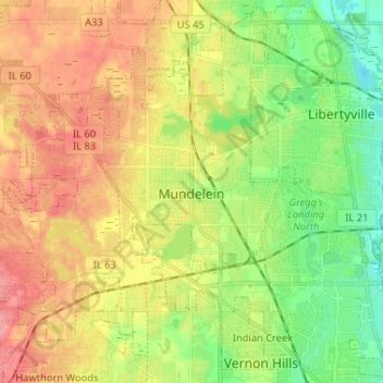
Nome: Mapa topográfico Mundelein, altitude, relevo.
Local: Mundelein, Lake County, Illinois, 60060, United States (42.22754 -88.06818 42.29962 -87.93859)
Altitude média: 231 m
Altitude mínima: 193 m
Altitude máxima: 271 m
Faça uma doação
Outros mapas topográficos
Clique em um mapa para visualizar sua topografia, sua altitude e seu relevo.
Faça uma doação
Faça uma doação
Faça uma doação
Lake Naomi
United States > Illinois > Lake County > Hawthorn Woods > White Birch Lakes
Altitude média: 261 m