
Faça uma doação
Mapa topográfico San Anselmo
Clique no mapa para exibir a altitude.
Faça uma doação
San Anselmo
San Anselmo (Spanish for '"Saint Anselm"') is an incorporated town in Marin County, California, United States. San Anselmo is located 1.5 miles (2.4 km) west of San Rafael, at an elevation of 46 feet (14 m). It is located about 20 miles (32 km) north of San Francisco. The town is bordered by San Rafael to the east, Fairfax to the west, and Ross to the south. Mount Tamalpais dominates the view to the south. The population was 12,830 at the 2020 census.
Faça uma doação
Sobre este mapa
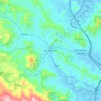
Nome: Mapa topográfico San Anselmo, altitude, relevo.
Altitude média: 99 m
Altitude mínima: -3 m
Altitude máxima: 550 m
Faça uma doação
Outros mapas topográficos
Clique em um mapa para visualizar sua topografia, sua altitude e seu relevo.
Corte Madera
United States > California > Marin County
Corte Madera (/ˈkɔːrtə məˈdɛrə/; Spanish for "Chop Wood") is an incorporated town in Marin County, California. Corte Madera is located 3.25 miles (5.2 km) south of San Rafael, at an elevation of 39 feet (12 m). The population was 10,222 at the 2020 census. The town was named after the Spanish…
Altitude média: 52 m
Cascade Canyon Open Space Preserve
United States > California > Marin County > Fairfax > Manor
Altitude média: 191 m
Faça uma doação
Tamalpais-Homestead Valley
United States > California > Marin County > Mill Valley
Altitude média: 92 m
San Geronimo
United States > California > Marin County
San Geronimo (Spanish: San Gerónimo, meaning "St. Jerome") is a census-designated place (CDP) located in the San Geronimo Valley in Marin County, California in the United States. San Geronimo is located with Lagunitas-Forest Knolls to its west, Woodacre to its east, and 8 miles (13 km) southwest of downtown…
Altitude média: 234 m