
Faça uma doação
Mapa topográfico Lorgues
Clique no mapa para exibir a altitude.
Faça uma doação
Lorgues
In terms of geology Lorgues is, for the most part, underlain by Triassic and Jurassic limestones which give rise to gentle hills and narrow flat-bottomed valleys, the most important of which are the valleys of the rivers Argens and Florièye which border the commune on the south and east. The town centre stands at an elevation of 210m, with the hill of Saint Ferréol to the east rising to 320m.
Faça uma doação
Sobre este mapa
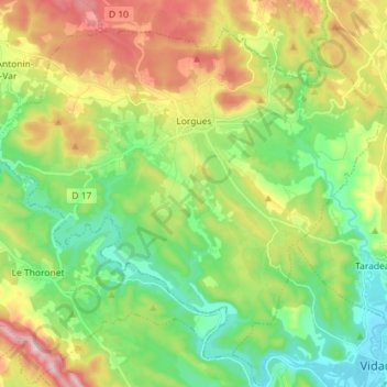
Nome: Mapa topográfico Lorgues, altitude, relevo.
Altitude média: 189 m
Altitude mínima: 50 m
Altitude máxima: 428 m
Faça uma doação
Outros mapas topográficos
Clique em um mapa para visualizar sua topografia, sua altitude e seu relevo.
Faça uma doação
Ruines du Barrage de Malpasset
France > Provence-Alpes-Côte d'Azur > Var > Fréjus
Altitude média: 118 m
Val d'Esquieres
France > Provence-Alpes-Côte d'Azur > Var > Roquebrune-sur-Argens
Altitude média: 82 m
Plage de Bonporteau
France > Provence-Alpes-Côte d'Azur > Var > Cavalaire-sur-Mer
Altitude média: 41 m
Faça uma doação
Faça uma doação
Faça uma doação
Faça uma doação
Les Aires Longues
France > Provence-Alpes-Côte d'Azur > Var > Ginasservis > Les Aires Longues
Altitude média: 411 m
Draguignan
France > Provence-Alpes-Côte d'Azur > Var > Draguignan > Draguignan
The elevation is 200 m. The highest hill near Draguignan is Malmont (551 m). The main river near Draguignan is the Nartuby.
Altitude média: 288 m
Île des Embiez
France > Provence-Alpes-Côte d'Azur > Var > Six-Fours-les-Plages > Le Brusc
Altitude média: 2 m
Faça uma doação
Jospeh Allet
France > Provence-Alpes-Côte d'Azur > Var > Draguignan > Draguignan > Saint François
Altitude média: 207 m
Faça uma doação