
Mapa topográfico Gurdaspur
Mapa interativo
Clique no mapa para exibir a altitude.
Sobre este mapa
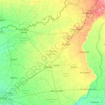
Nome: Mapa topográfico Gurdaspur, altitude, relevo.
Local: Gurdaspur, Punjab, India (31.59387 74.88848 32.21387 75.60134)
Altitude média: 247 m
Altitude mínima: 225 m
Altitude máxima: 294 m
All the Tehsils of the district namely Gurdaspur, Batala and Dera Baba Nanak are plain and similar to the rest of the Punjab plains in structure. The landscape of the district has varied topography comprising undulating plan, the flood plains of the Ravi and the Beas and the upland plain.
Outros mapas topográficos
Clique em um mapa para visualizar sua topografia, sua altitude e seu relevo.