
Faça uma doação
Mapa topográfico Kahoolawe
Clique no mapa para exibir a altitude.
Faça uma doação
Sobre este mapa
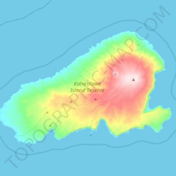
Nome: Mapa topográfico Kahoolawe, altitude, relevo.
Local: Kahoolawe, Maui County, Hawaii, United States (20.50092 -156.70044 20.60392 -156.53181)
Altitude média: 70 m
Altitude mínima: -1 m
Altitude máxima: 449 m
Faça uma doação
Outros mapas topográficos
Clique em um mapa para visualizar sua topografia, sua altitude e seu relevo.
Faça uma doação
Kula
United States > Hawaii > Maui County
Kula is a district and census-designated place (CDP) of Maui, Hawaii, that stretches across the "up-country", the western-facing slopes of Haleakalā, from Makawao to Kanaio. Most of the residential areas lie between about 500 to 1,100 m (1,600 to 3,600 ft) in elevation. The district has traditionally been…
Altitude média: 740 m
Faça uma doação
Haleakalā Observatories
United States > Hawaii > Maui County
The Haleakalā Observatory, also known as the Haleakalā High Altitude Observatory Site, is Hawaii's first astronomical research observatory. It is located on the island of Maui and is owned by the Institute for Astronomy of the University of Hawaiʻi, which operates some of the facilities on the site and…
Altitude média: 2.811 m
Faça uma doação
Kula
United States > Hawaii > Maui County
Kula is a census-designated place (CDP) of Maui, Hawaii. It stretches across Upcountry Maui, the western-facing slopes of Haleakalā. Most residential areas lie between about 500 to 1,100 m (1,600 to 3,600 ft) in elevation. The district is distinct from the generally hotter and busier coastal areas. The…
Altitude média: 740 m
Faça uma doação
Molokini Shoal Marine Life Conservation District
United States > Hawaii > Maui County
Altitude média: 0 m
Faça uma doação
Faça uma doação