
Mapa topográfico Behchokǫ̀
Mapa interativo
Clique no mapa para exibir a altitude.
Sobre este mapa
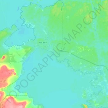
Nome: Mapa topográfico Behchokǫ̀, altitude, relevo.
Altitude média: 169 m
Altitude mínima: 152 m
Altitude máxima: 257 m
As the community grew alongside increased services such as a mission-run hospital and church, the government viewed the topography of Fort Rae as unsuitable for expansion. In the 1950s there was concern about runoff from animal and human wastes contaminating sources of drinking water, and the government proposed constructing a new settlement on more favourable terrain. The community became known as Edzo and was located on the west side of the Frank Channel opposite Fort Rae a 24 km (15 mi) drive away. Most of the Dene families refused to move from their community so that Rae (62°49′43″N 116°03′08″W / 62.82861°N 116.05222°W / 62.82861; -116.05222 (Rae)) and Edzo (62°46′30″N 116°02′26″W / 62.77500°N 116.04056°W / 62.77500; -116.04056 (Edzo)) (Rae-Edzo) became two separate communities although administered together.
Outros mapas topográficos
Clique em um mapa para visualizar sua topografia, sua altitude e seu relevo.
Lac de Gras
Canada > Northwest Territories > North Slave Region
Lac de Gras, North Slave Region, Northwest Territories, Canada
Altitude média: 445 m
Yellowknife
Canada > Northwest Territories > North Slave Region
Yellowknife, North Slave Region, Northwest Territories, Canada
Altitude média: 185 m