
Obrigado por apoiar este site ❤️
Faça uma doação
Faça uma doação
Mapa topográfico Priddis
Clique no mapa para exibir a altitude.
Obrigado por apoiar este site ❤️
Faça uma doação
Faça uma doação
Priddis
Priddis is a hamlet in Alberta, Canada within Foothills County. It is located in the foothills of the Canadian Rockies at an elevation of 1,160 metres (3,810 ft). The hamlet is located southwest of the intersection of the Cowboy Trail (Highway 22) and Highway 22X, approximately 10 kilometres (6.2 mi) west of Calgary's city limits.
Obrigado por apoiar este site ❤️
Faça uma doação
Faça uma doação
Sobre este mapa
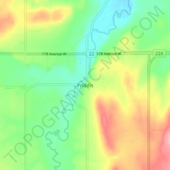
Nome: Mapa topográfico Priddis, altitude, relevo.
Local: Priddis, Foothills County, Alberta, Canada (50.86479 -114.34574 50.90479 -114.30574)
Altitude média: 1.193 m
Altitude mínima: 1.146 m
Altitude máxima: 1.262 m
Obrigado por apoiar este site ❤️
Faça uma doação
Faça uma doação
Outros mapas topográficos
Clique em um mapa para visualizar sua topografia, sua altitude e seu relevo.