
Faça uma doação
Mapa topográfico Gundagai
Clique no mapa para exibir a altitude.
Faça uma doação
Gundagai
Gundagai is an inland town with an elevation of 232 metres (761 ft). Almost all of the shire is located in the South West Slopes bio-region and is part of the Riverina agricultural region. The eastern part of the shire is considered part of the South Eastern Highlands bioregion.
Faça uma doação
Sobre este mapa
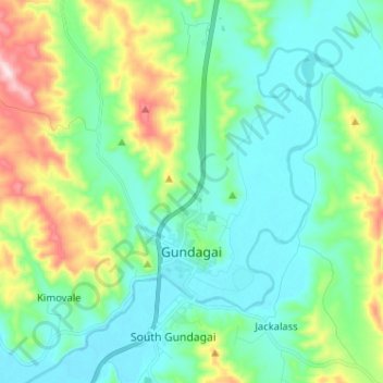
Nome: Mapa topográfico Gundagai, altitude, relevo.
Altitude média: 309 m
Altitude mínima: 208 m
Altitude máxima: 622 m
Faça uma doação
Outros mapas topográficos
Clique em um mapa para visualizar sua topografia, sua altitude e seu relevo.
Kangaroo Mount
Australia > New South Wales > Cootamundra-Gundagai Regional Council > Gobarralong
Altitude média: 255 m
Burrinjuck Dam
Australia > New South Wales > Cootamundra-Gundagai Regional Council > Wee Jasper > Adjungbilly
Altitude média: 548 m
The Three Sisters
Australia > New South Wales > Cootamundra-Gundagai Regional Council > Cootamundra
Altitude média: 403 m