
Faça uma doação
Mapa topográfico Garibaldi Lake
Clique no mapa para exibir a altitude.
Faça uma doação
Garibaldi Lake
All recreational activities in the area are governed by the regulations of Garibaldi Provincial Park. Primary access to the lake is via the 9 km (5.5 mi) long Garibaldi Lake Trail, which gains approximately 920 m (3,020 ft) of elevation from the Rubble Creek Trailhead. There are campgrounds and day-use shelters on the west shore of Garibaldi Lake, and also farther northwest at Taylor Meadows. Nearly all sites have tent platforms to protect the surrounding ecosystem. During the summer, access to the eastern end of the lake is severely limited, since no trails have been constructed along the steep and unstable slopes which plunge directly into the lake. During winter, the lake is typically frozen from late December to late April, allowing backcountry skiers and snowshoers to easily reach the far shore. A pair of small alpine huts are located in Sphinx Bay on the eastern shore and Sentinel Bay at the southeastern tip of the lake.
Faça uma doação
Sobre este mapa
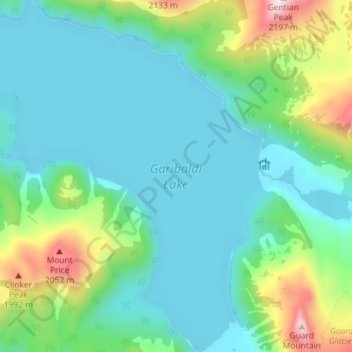
Nome: Mapa topográfico Garibaldi Lake, altitude, relevo.
Altitude média: 1.620 m
Altitude mínima: 1.460 m
Altitude máxima: 2.175 m
Faça uma doação
Outros mapas topográficos
Clique em um mapa para visualizar sua topografia, sua altitude e seu relevo.
Panorama Ridge
Canada > British Columbia > Squamish-Lillooet Regional District > Area D (Elaho/Garibaldi)
Altitude média: 1.786 m
Britannia Beach
Canada > British Columbia > Squamish-Lillooet Regional District > Area D (Elaho/Garibaldi)
Altitude média: 208 m
Elfin Lakes
Canada > British Columbia > Squamish-Lillooet Regional District > Area D (Elaho/Garibaldi)
Altitude média: 1.331 m
Cheekye River
Canada > British Columbia > Squamish-Lillooet Regional District > Area D (Elaho/Garibaldi)
Altitude média: 634 m
Faça uma doação
The Black Tusk
Canada > British Columbia > Squamish-Lillooet Regional District > Area D (Elaho/Garibaldi)
Altitude média: 1.874 m
Brandywine
Canada > British Columbia > Squamish-Lillooet Regional District > Area D (Elaho/Garibaldi)
Altitude média: 515 m
The Black Tusk (True Summit)
Canada > British Columbia > Squamish-Lillooet Regional District > Area D (Elaho/Garibaldi)
Altitude média: 1.875 m
Slhanay
Canada > British Columbia > Squamish-Lillooet Regional District > Area D (Elaho/Garibaldi)
Altitude média: 363 m
Faça uma doação
Mount Price
Canada > British Columbia > Squamish-Lillooet Regional District > Area D (Elaho/Garibaldi)
Mount Price is a small stratovolcano in the Garibaldi Ranges of the Pacific Ranges in southwestern British Columbia, Canada. It has an elevation of 2,049 metres (6,722 feet) and rises above the surrounding landscape on the western side of Garibaldi Lake in New Westminster Land District. The mountain contains a…
Altitude média: 1.672 m
Barrier Lake
Canada > British Columbia > Squamish-Lillooet Regional District > Area D (Elaho/Garibaldi)
Altitude média: 1.405 m
Furry Creek
Canada > British Columbia > Squamish-Lillooet Regional District > Area D (Elaho/Garibaldi)
Altitude média: 224 m
Deeks Lake
Canada > British Columbia > Squamish-Lillooet Regional District > Area D (Elaho/Garibaldi)
Altitude média: 1.237 m
Faça uma doação
Garibaldi
Canada > British Columbia > Squamish-Lillooet Regional District > Area D (Elaho/Garibaldi)
Altitude média: 417 m
Minaty Bay
Canada > British Columbia > Squamish-Lillooet Regional District > Area D (Elaho/Garibaldi)
Altitude média: 91 m
Mount Brew
Canada > British Columbia > Squamish-Lillooet Regional District > Area D (Elaho/Garibaldi)
Altitude média: 1.513 m
Metal Dome
Canada > British Columbia > Squamish-Lillooet Regional District > Area D (Elaho/Garibaldi)
Altitude média: 1.678 m
Faça uma doação
Whistler Olympic Park
Canada > British Columbia > Squamish-Lillooet Regional District > Area D (Elaho/Garibaldi)
Altitude média: 954 m
Mount Cayley
Canada > British Columbia > Squamish-Lillooet Regional District > Area D (Elaho/Garibaldi)
Mount Cayley is an eroded but potentially active stratovolcano in the Pacific Ranges of southwestern British Columbia, Canada. Located 45 km (28 mi) north of Squamish and 24 km (15 mi) west of Whistler, the volcano resides on the edge of the Powder Mountain Icefield. It consists of massif that towers over the…
Altitude média: 1.896 m
Helm Glacier
Canada > British Columbia > Squamish-Lillooet Regional District > Area D (Elaho/Garibaldi)
Altitude média: 1.949 m
Sentinel Glacier
Canada > British Columbia > Squamish-Lillooet Regional District > Area D (Elaho/Garibaldi)
Altitude média: 1.856 m
Faça uma doação
The Table
Canada > British Columbia > Squamish-Lillooet Regional District > Area D (Elaho/Garibaldi)
Altitude média: 1.623 m
Mount Fee
Canada > British Columbia > Squamish-Lillooet Regional District > Area D (Elaho/Garibaldi)
Mount Fee is a volcanic peak in the Pacific Ranges of the Coast Mountains in southwestern British Columbia, Canada. It is located 13 km (8.1 mi) south of Callaghan Lake and 21 km (13 mi) west of the resort town of Whistler. With a summit elevation of 2,162 m (7,093 ft) and a topographic prominence of 312 m…
Altitude média: 1.771 m
Ring Mountain
Canada > British Columbia > Squamish-Lillooet Regional District > Area D (Elaho/Garibaldi)
Altitude média: 1.816 m
Furry Creek
Canada > British Columbia > Squamish-Lillooet Regional District > Area D (Elaho/Garibaldi)
Altitude média: 224 m
Faça uma doação
The Table
Canada > British Columbia > Squamish-Lillooet Regional District > Area D (Elaho/Garibaldi)
Altitude média: 1.623 m
Furry Creek
Canada > British Columbia > Squamish-Lillooet Regional District > Area D (Elaho/Garibaldi)
Altitude média: 224 m
Ring Mountain
Canada > British Columbia > Squamish-Lillooet Regional District > Area D (Elaho/Garibaldi)
Altitude média: 1.816 m
Mt. Mulligan
Canada > British Columbia > Squamish-Lillooet Regional District > Area D (Elaho/Garibaldi)
Altitude média: 1.159 m
Faça uma doação
The Copilot
Canada > British Columbia > Squamish-Lillooet Regional District > Area D (Elaho/Garibaldi)
Altitude média: 1.466 m