
Faça uma doação
Mapa topográfico Orpierre
Clique no mapa para exibir a altitude.
Faça uma doação
Sobre este mapa
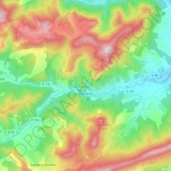
Nome: Mapa topográfico Orpierre, altitude, relevo.
Altitude média: 910 m
Altitude mínima: 624 m
Altitude máxima: 1.304 m
Faça uma doação
Outros mapas topográficos
Clique em um mapa para visualizar sua topografia, sua altitude e seu relevo.
Serre Chevalier
France > Provence-Alpes-Côte d'Azur > Hautes-Alpes > Puy-Saint-André
The maximum elevation for skiing is at Telesiege Yret at 2,800 m (9,190 ft) above sea level, and the minimum is 1,200 m (3,940 ft), a total vertical drop of 1,600 m (5,250 ft). One of the outstanding features of Serre Chevalier is the wooded nature of the slopes. The timber line is at 2,150 m (7,050 ft),…
Altitude média: 2.256 m
Col du Lautaret
France > Provence-Alpes-Côte d'Azur > Hautes-Alpes > Le Monêtier-les-Bains
From the west, the climb starts at Les Clapier, near Le Bourg-d'Oisans, from where the climb is 34.2 km (21.3 mi) long, gaining 1,312 m (4,304 ft) in altitude, at an average gradient of 3.8%, with the steepest section being at 7.5% in the first kilometre.
Altitude média: 2.261 m
Lucis
France > Provence-Alpes-Côte d'Azur > Hautes-Alpes > Villar-Saint-Pancrace
Altitude média: 1.326 m
Faça uma doação
Orcières-Merlette
France > Provence-Alpes-Côte d'Azur > Hautes-Alpes > Orcières
Altitude média: 1.874 m
Plan de la Loubiere
France > Provence-Alpes-Côte d'Azur > Hautes-Alpes > La Roche-de-Rame
Altitude média: 2.056 m
Les Chaussendents
France > Provence-Alpes-Côte d'Azur > Hautes-Alpes > La Chapelle-en-Valgaudémar
Altitude média: 1.619 m
Faça uma doação
La Rua
France > Provence-Alpes-Côte d'Azur > Hautes-Alpes > Molines-en-Queyras
Altitude média: 1.982 m
Faça uma doação
Station de Ski de Réallon
France > Provence-Alpes-Côte d'Azur > Hautes-Alpes > Réallon
Altitude média: 1.494 m
Les Allouviers
France > Provence-Alpes-Côte d'Azur > Hautes-Alpes > Gap > Romette
Altitude média: 957 m
Les Payas
France > Provence-Alpes-Côte d'Azur > Hautes-Alpes > Saint-Bonnet-en-Champsaur
Altitude média: 1.325 m
Faça uma doação
Le Château d'Ancelle
France > Provence-Alpes-Côte d'Azur > Hautes-Alpes > Ancelle
Altitude média: 1.407 m
Les Forests
France > Provence-Alpes-Côte d'Azur > Hautes-Alpes > Saint-Léger-les-Mélèzes
Altitude média: 1.383 m