
Mapa topográfico Saint-Genis-Pouilly
Mapa interativo
Clique no mapa para exibir a altitude.
Sobre este mapa
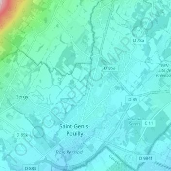
Nome: Mapa topográfico Saint-Genis-Pouilly, altitude, relevo.
Altitude média: 477 m
Altitude mínima: 425 m
Altitude máxima: 911 m
Saint-Genis-Pouilly is composed of two market towns (Saint-Genis and Pouilly) and two hamlets (Pregnin and Flies). The two market towns have both continued to expand and now practically merge into one, however the two hamlets still remain separate from each other and from the two towns. The elevation of the commune varies from 419 m (at the extreme south of the commune, to the confluence of the rivers Allondon and Nant de l'Ecra) to 502 m (at the extreme north of the commune, in the village of Flies). The commune is situated at the limit between the plains surrounding Geneva and the first foothills of the Jura. As indicated on the map opposite, the communes surrounding Saint-Genis-Pouilly are: Thoiry, Sergy, Crozet, Chevry, Prévessin-Moëns and Satigny (Swiss).
Outros mapas topográficos
Clique em um mapa para visualizar sua topografia, sua altitude e seu relevo.
Port
France > Auvergne-Rhône-Alpes > Ain
Port, Nantua, Ain, Auvergne-Rhône-Alpes, Metropolitan France, 01460, France
Altitude média: 606 m
Les Huguets
France > Auvergne-Rhône-Alpes > Ain > Saint-Didier-sur-Chalaronne
Les Huguets, Saint-Didier-sur-Chalaronne, Bourg-en-Bresse, Ain, Auvergne-Rhône-Alpes, Metropolitan France, 01140, France
Altitude média: 184 m
Saint-Jérôme
France > Auvergne-Rhône-Alpes > Ain > Boyeux-Saint-Jérôme
Saint-Jérôme, Boyeux-Saint-Jérôme, Nantua, Ain, Auvergne-Rhône-Alpes, Metropolitan France, 01640, France
Altitude média: 613 m
Joyeux
France > Auvergne-Rhône-Alpes > Ain
Joyeux, Belley, Ain, Auvergne-Rhône-Alpes, Metropolitan France, 01800, France
Altitude média: 288 m
Culoz
France > Auvergne-Rhône-Alpes > Ain > Culoz
Culoz, Belley, Ain, Auvergne-Rhône-Alpes, Metropolitan France, 01350, France
Altitude média: 449 m
Bourg-en-Bresse
France > Auvergne-Rhône-Alpes > Ain > Bourg-en-Bresse
Bourg-en-Bresse, Ain, Auvergne-Rhône-Alpes, Metropolitan France, 01000, France
Altitude média: 238 m
Sainte-Julie
France > Auvergne-Rhône-Alpes > Ain
Sainte-Julie, Belley, Ain, Auvergne-Rhône-Alpes, Metropolitan France, 01150, France
Altitude média: 222 m