
Mapa topográfico Zernez
Mapa interativo
Clique no mapa para exibir a altitude.
Sobre este mapa
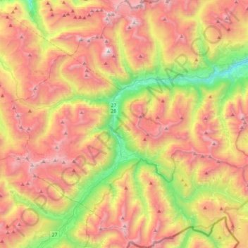
Nome: Mapa topográfico Zernez, altitude, relevo.
Altitude média: 2.297 m
Altitude mínima: 1.199 m
Altitude máxima: 3.366 m
Lai da Ova Spin is a compensation reservoir on the river Spöl. It is located in the upper areas of the Lower Engadine valley (Romansh: Engiadina Bassa). It is located at an elevation of 1,473 m (4,833 ft) and is connected to the railway network of the Rhätische Bahn. In Zernez, the stream Spöl empties into the Inn (Romansh: En).
Outros mapas topográficos
Clique em um mapa para visualizar sua topografia, sua altitude e seu relevo.
Swiss National Park
Switzerland > Grisons > Zernez
Swiss National Park, 28, Punt la Drossa, Zernez, Region Engiadina Bassa/Val Müstair, Grisons, 7530, Switzerland
Altitude média: 2.283 m