
Obrigado por apoiar este site ❤️
Faça uma doação
Faça uma doação
Mapa topográfico Hempstead
Clique no mapa para exibir a altitude.
Obrigado por apoiar este site ❤️
Faça uma doação
Faça uma doação
Sobre este mapa
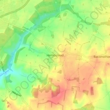
Nome: Mapa topográfico Hempstead, altitude, relevo.
Altitude média: 68 m
Altitude mínima: 35 m
Altitude máxima: 98 m
Obrigado por apoiar este site ❤️
Faça uma doação
Faça uma doação
Outros mapas topográficos
Clique em um mapa para visualizar sua topografia, sua altitude e seu relevo.
Knapton
United Kingdom > England > Norfolk > North Norfolk
The present church dates from mainly the 14th century. The tower is set into the north west corner of the building. The porch is on the southern elevation. Atop of the church there is a weathervane designed by J.S. Cotman an artist famed as a member of the Norwich school. Inside there is a 13th-century font on…
Altitude média: 29 m
Obrigado por apoiar este site ❤️
Faça uma doação
Faça uma doação
Obrigado por apoiar este site ❤️
Faça uma doação
Faça uma doação
Obrigado por apoiar este site ❤️
Faça uma doação
Faça uma doação