
Obrigado por apoiar este site ❤️
Faça uma doação
Faça uma doação
Mapa topográfico Allenspark
Clique no mapa para exibir a altitude.
Obrigado por apoiar este site ❤️
Faça uma doação
Faça uma doação
Allenspark
Allenspark is located in northwest Boulder County within Roosevelt National Forest in the Front Range of the Colorado Rockies. The western edge of the community is the boundary of Rocky Mountain National Park. State Highway 7 passes through the community, leading north 15 miles (24 km) to Estes Park and east 19 miles (31 km) to Lyons. The center of Allenspark is at an elevation of 8,428 feet (2,569 m).
Obrigado por apoiar este site ❤️
Faça uma doação
Faça uma doação
Sobre este mapa
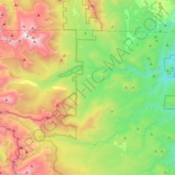
Nome: Mapa topográfico Allenspark, altitude, relevo.
Local: Allenspark, Boulder County, Colorado, United States (40.12942 -105.67155 40.26128 -105.41062)
Altitude média: 2.874 m
Altitude mínima: 1.996 m
Altitude máxima: 4.333 m
Obrigado por apoiar este site ❤️
Faça uma doação
Faça uma doação
Outros mapas topográficos
Clique em um mapa para visualizar sua topografia, sua altitude e seu relevo.