
Mapa topográfico Whitehorse
Mapa interativo
Clique no mapa para exibir a altitude.
Sobre este mapa
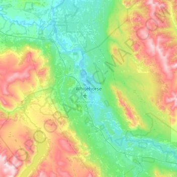
Nome: Mapa topográfico Whitehorse, altitude, relevo.
Local: Whitehorse, Yukon, Canada (60.56157 -135.21493 60.88157 -134.89493)
Altitude média: 1.008 m
Altitude mínima: 629 m
Altitude máxima: 1.894 m
Whitehorse has a subarctic climate (Köppen climate classification: Dfc) and lies in the rain shadow of the Coast Mountains, causing precipitation totals to be quite low year-round. Due to the city's location in the Whitehorse valley, the climate is milder than other comparable northern communities such as Yellowknife, however during cold snaps it is not uncommon for temperatures to drop below −40 °C (−40 °F). With an average annual temperature of −0.1 °C (31.8 °F) Whitehorse is the warmest place in the Yukon. The temperature measurements for the city are taken at the airport. The Whitehorse Riverdale weather station situated at a lower elevation than the airport is even warmer at 0.2 °C (32.4 °F).
Outros mapas topográficos
Clique em um mapa para visualizar sua topografia, sua altitude e seu relevo.
Kluane National Park and Reserve
Kluane National Park and Reserve, Yukon, Canada
Altitude média: 1.536 m
Two Mile Village
Canada > Yukon > Watson Lake
Two Mile Village, Watson Lake, Yukon, Y0A 1C0, Canada
Altitude média: 703 m
Destruction Bay
Canada > Yukon > Destruction Bay
Destruction Bay, Yukon, Y0B 1H0, Canada
Altitude média: 893 m
Dawson City
Canada > Yukon > Dawson City > Dawson City
Dawson City, Yukon, Y0B 1G0, Canada
Altitude média: 510 m
Yukon, Unorganized
City of Whitehorse, Yukon, Unorganized, Yukon, Canada
Altitude média: 1.010 m
Swift River
Canada > Yukon > Swift River
Swift River, Yukon, Unorganized, Yukon, Canada
Altitude média: 1.086 m