
Mapa topográfico River Severn
Mapa interativo
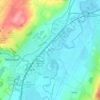
Clique no mapa para exibir a altitude.
Sobre este mapa
Nome: Mapa topográfico River Severn, altitude, relevo.
Altitude média: 92 m
Altitude mínima: 65 m
Altitude máxima: 178 m
The River Severn (Welsh: Afon Hafren, pronounced [ˈavɔn ˈhavrɛn]), at 220 miles (354 km) long, is the longest river in Great Britain. It is also the river with the most voluminous flow of water by far in all of England and Wales, with an average flow rate of 107 m3/s (3,800 cu ft/s) at Apperley, Gloucestershire. It rises in the Cambrian Mountains in mid Wales, at an altitude of 2,001 feet (610 m), on the Plynlimon massif, which lies close to the Ceredigion/Powys border near Llanidloes. The river then flows through Shropshire, Worcestershire and Gloucestershire. The county towns of Shrewsbury, Worcester and Gloucester lie on its course.
Outros mapas topográficos
Clique em um mapa para visualizar sua topografia, sua altitude e seu relevo.
Powis Castle
United Kingdom > Wales > Powys > Welshpool > Belan
Powis Castle, Red Lane, Belan, Welshpool, Powys, Wales, SY21 8RJ, United Kingdom
Altitude média: 123 m