
Faça uma doação
Mapa topográfico Mount Buller
Clique no mapa para exibir a altitude.
Faça uma doação
Mount Buller
Due to its far south-western location in the alpine region, Mount Buller is more susceptible to cold airmasses which allow it to record some of the lowest maximum temperatures and daytime readings in the country, despite being considerably lower in elevation than other mountain sites to the north-east. On 05 September 1995, a maximum temperature of just −6.2 °C (20.8 °F) was registered at Mount Buller; the same day at Thredbo Top Station saw a maximum of −6.0 °C (21.2 °F), some 250 metres (820 ft) higher than Buller. On 03 February 2023, at the height of summer, Mount Buller reached a top of just 0.9 °C (33.6 °F).
Faça uma doação
Sobre este mapa
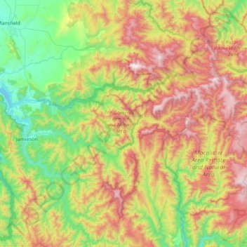
Nome: Mapa topográfico Mount Buller, altitude, relevo.
Altitude média: 824 m
Altitude mínima: 256 m
Altitude máxima: 1.779 m
Faça uma doação
Outros mapas topográficos
Clique em um mapa para visualizar sua topografia, sua altitude e seu relevo.
Melbourne
Australia > Victoria > Melbourne
Melbourne is also prone to isolated convective showers forming when a cold pool crosses the state, especially if there is considerable daytime heating. These showers are often heavy and can include hail, squalls, and significant drops in temperature, but they often pass through very quickly with a rapid…
Altitude média: 49 m
Ballarat
Ballarat has a moderate oceanic climate (Köppen climate classification Cfb) with four distinct seasons. Its elevation, ranging between 400 and 630 metres (1,310 and 2,070 feet) above sea level, causes its mean monthly temperatures to tend to be on average 3 to 5 °C (5 to 9 °F) below those of Melbourne,…
Altitude média: 470 m
Faça uma doação
Faça uma doação
Faça uma doação
Faça uma doação
Faça uma doação
Faça uma doação
Faça uma doação
Faça uma doação
Faça uma doação
Faça uma doação
Faça uma doação
Faça uma doação
Faça uma doação
Faça uma doação