
Mapa topográfico Bloemfontein
Mapa interativo
Clique no mapa para exibir a altitude.
Sobre este mapa
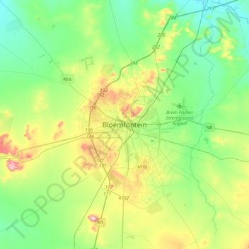
Nome: Mapa topográfico Bloemfontein, altitude, relevo.
Altitude média: 1.374 m
Altitude mínima: 1.283 m
Altitude máxima: 1.593 m
Situated at an elevation of 1,395 m (4,577 ft) above sea level, the city is home to 256,185 (as of 2011) residents and forms part of the Mangaung Metropolitan Municipality which has a population of 747,431. It was one of the host cities for the 2010 FIFA World Cup.