
Mapa topográfico Kemmel
Mapa interativo
Clique no mapa para exibir a altitude.
Sobre este mapa
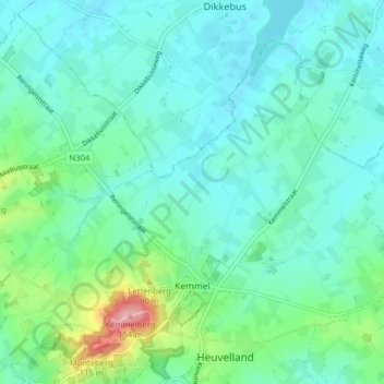
Nome: Mapa topográfico Kemmel, altitude, relevo.
Local: Kemmel, Heuvelland, Ieper, West-Vlaanderen, 8956, België (50.77534 2.79253 50.81498 2.87187)
Altitude média: 49 m
Altitude mínima: 23 m
Altitude máxima: 153 m
Outros mapas topográficos
Clique em um mapa para visualizar sua topografia, sua altitude e seu relevo.
Nieuwkerke
België > West-Vlaanderen > Ieper > Heuvelland > Nieuwkerke
Nieuwkerke, Heuvelland, Ieper, West-Vlaanderen, Vlaanderen, 8950, België
Altitude média: 29 m
De Klijte
België > West-Vlaanderen > Ieper > Heuvelland
De Klijte, Heuvelland, Ieper, West-Vlaanderen, 8956, België
Altitude média: 51 m
Dranouter
België > West-Vlaanderen > Ieper > Heuvelland
Dranouter, Heuvelland, Ieper, West-Vlaanderen, 8951, België
Altitude média: 50 m
Westouter
België > West-Vlaanderen > Ieper > Heuvelland
Westouter, Heuvelland, Ieper, West-Vlaanderen, Vlaanderen, 8954, België
Altitude média: 59 m
Kemmelberg
België > West-Vlaanderen > Ieper > Heuvelland
Kemmelberg, Heuvelland, Ieper, West-Vlaanderen, Vlaanderen, 8956, België
Altitude média: 68 m
Loker
België > West-Vlaanderen > Ieper > Heuvelland
Loker, Heuvelland, Ieper, West-Vlaanderen, 8958, België
Altitude média: 73 m