
Obrigado por apoiar este site ❤️
Faça uma doação
Faça uma doação
Mapa topográfico Hill Top
Clique no mapa para exibir a altitude.
Obrigado por apoiar este site ❤️
Faça uma doação
Faça uma doação
Sobre este mapa
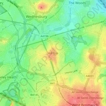
Nome: Mapa topográfico Hill Top, altitude, relevo.
Altitude média: 138 m
Altitude mínima: 111 m
Altitude máxima: 174 m
Obrigado por apoiar este site ❤️
Faça uma doação
Faça uma doação
Outros mapas topográficos
Clique em um mapa para visualizar sua topografia, sua altitude e seu relevo.
Causeway Green Park
United Kingdom > England > Sandwell > Causeway Green > The Ashes
Altitude média: 184 m
Rowley Hills
United Kingdom > England > Sandwell > Tividale
The largest hill, Turner's Hill, is the highest point in the West Midlands county, with an altitude of 269 metres (883 ft) above sea level. Views from the summit include the Clee Hills, Clent Hills, Cannock Chase, and much of Birmingham and the Black Country. The height has also led to the construction of two…
Altitude média: 182 m