
Faça uma doação
Mapa topográfico Bouvesse-Quirieu
Clique no mapa para exibir a altitude.
Faça uma doação
Bouvesse-Quirieu
Bouvesse-Quirieu is a modest rural commune situated in a hilly region. The village stands at an altitude of 220 m and is located about 30 km north-east of Bourgoin-Jallieu, in the northern part of the Isère department.
Faça uma doação
Sobre este mapa
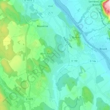
Nome: Mapa topográfico Bouvesse-Quirieu, altitude, relevo.
Altitude média: 254 m
Altitude mínima: 198 m
Altitude máxima: 469 m
Faça uma doação
Outros mapas topográficos
Clique em um mapa para visualizar sua topografia, sua altitude e seu relevo.
Faça uma doação
Lac de Paladru
France > Auvergne-Rhône-Alpes > Isère > Paladru
The lake area has a cool temperate climate. The north–south orientation and relatively high altitude means the average temperature is around 10 °C. Rainfall is irregular, with most rain occurring in June and October with the rise of humid air masses from the Mediterranean. January is the coldest month, with…
Altitude média: 569 m
Faça uma doação
Faça uma doação
Faça uma doação
Hameau des Farlaix
France > Auvergne-Rhône-Alpes > Isère > Autrans-Méaudre en Vercors > Méaudre
Altitude média: 1.155 m
Faça uma doação
Roche Béranger
France > Auvergne-Rhône-Alpes > Isère > Chamrousse
The road to the ski station starts at Uriage-les-Bains from where the climb is 19 km (12 mi) long, gaining 1,235 m (4,052 ft) in elevation, at an average gradient of 6.5%. There are several sections in excess off 11% in the early stages of the climb. For the Tour de France, the summit is at an elevation of…
Altitude média: 1.561 m
Faça uma doação
Faça uma doação
Faça uma doação
Faça uma doação
Faça uma doação
Faça uma doação