
Obrigado por apoiar este site ❤️
Faça uma doação
Faça uma doação
Mapa topográfico Barcelonnette
Clique no mapa para exibir a altitude.
Obrigado por apoiar este site ❤️
Faça uma doação
Faça uma doação
Barcelonnette
Barcelonnette is situated in the wide and fertile Ubaye Valley, of which it is the largest town. It lies at an elevation of 1132 m (3717 ft) on the right bank of the Ubaye River, and is surrounded by mountains which reach peaks of over 3000 m; the tallest of these is the Needle of Chambeyron at 3412 m. Barcelonnette is situated 210 km from Turin, 91 km from Nice and 68 km from Gap.
Obrigado por apoiar este site ❤️
Faça uma doação
Faça uma doação
Sobre este mapa
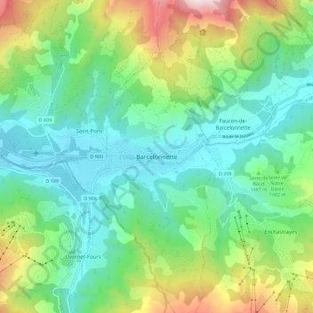
Nome: Mapa topográfico Barcelonnette, altitude, relevo.
Altitude média: 1.494 m
Altitude mínima: 1.103 m
Altitude máxima: 2.479 m
Obrigado por apoiar este site ❤️
Faça uma doação
Faça uma doação