
Obrigado por apoiar este site ❤️
Faça uma doação
Faça uma doação
Mapa topográfico Rubery
Clique no mapa para exibir a altitude.
Obrigado por apoiar este site ❤️
Faça uma doação
Faça uma doação
Sobre este mapa
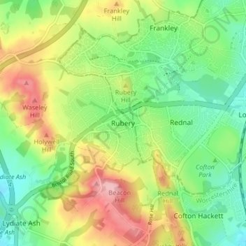
Nome: Mapa topográfico Rubery, altitude, relevo.
Altitude média: 213 m
Altitude mínima: 155 m
Altitude máxima: 298 m
Obrigado por apoiar este site ❤️
Faça uma doação
Faça uma doação
Outros mapas topográficos
Clique em um mapa para visualizar sua topografia, sua altitude e seu relevo.
Beacon Wood
United Kingdom > England > Worcestershire > Bromsgrove > Lydiate Ash
Altitude média: 210 m
Obrigado por apoiar este site ❤️
Faça uma doação
Faça uma doação
Clent
United Kingdom > England > Worcestershire > Bromsgrove
Because of the hilly topography of the parish the village consists of several distinct hamlets. These are Upper Clent (Clatterbach and the area around the parish church of St. Leonard), Lower Clent, Holy Cross, Adams Hill and Walton Pool. The Civil Parish of Clent also included part of the village of West…
Altitude média: 184 m
Obrigado por apoiar este site ❤️
Faça uma doação
Faça uma doação
Obrigado por apoiar este site ❤️
Faça uma doação
Faça uma doação
Obrigado por apoiar este site ❤️
Faça uma doação
Faça uma doação