
Mapa topográfico Cluj-Napoca
Mapa interativo
Clique no mapa para exibir a altitude.
Sobre este mapa
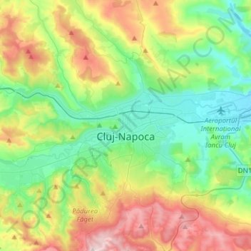
Nome: Mapa topográfico Cluj-Napoca, altitude, relevo.
Local: Cluj-Napoca, Cluj Metropolitan Area, Cluj, Romania (46.68997 23.49924 46.86183 23.71833)
Altitude média: 480 m
Altitude mínima: 307 m
Altitude máxima: 829 m
A wide variety of flora grow in the Cluj-Napoca Botanical Garden; some animals have also found refuge there. The city has a number of other parks, of which the largest is the Central Park. This park was founded during the 19th century and includes an artificial lake with an island, as well as the largest casino in the city, Chios. Other notable parks in the city are the Iuliu Hațieganu Park of the Babeș-Bolyai University, which features some sport facilities, the Hașdeu Park, within the eponymous student housing district, the high-elevation Cetățuia, and the Opera Park, behind the building of the Cluj-Napoca Romanian Opera.
Outros mapas topográficos
Clique em um mapa para visualizar sua topografia, sua altitude e seu relevo.
Peana
Romania > Cluj > Cluj-Napoca
Peana, Cluj-Napoca, Cluj Metropolitan Area, Cluj, 407271, Romania
Altitude média: 741 m
Mărtinești
Mărtinești, Tureni, Cluj Metropolitan Area, Cluj, 407563, Romania
Altitude média: 585 m
Muntele Cacovei
Muntele Cacovei, Băișoara, Cluj, 407071, Romania
Altitude média: 1.193 m
Muntele Băișorii
Muntele Băișorii, Băișoara, Cluj, 407068, Romania
Altitude média: 1.115 m
Câmpia Turzii
Romania > Cluj > Câmpia Turzii
Câmpia Turzii, Cluj, 405100, Romania
Altitude média: 329 m