
Mapa topográfico Alloa
Clique no mapa para exibir a altitude.
Sobre este mapa
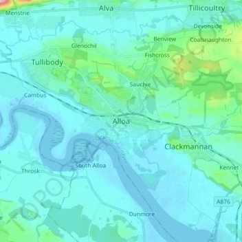
Nome: Mapa topográfico Alloa, altitude, relevo.
Local: Alloa, Clackmannanshire, Scotland, FK10 1JD, United Kingdom (56.07561 -3.83224 56.15561 -3.75224)
Altitude média: 22 m
Altitude mínima: -3 m
Altitude máxima: 212 m
Outros mapas topográficos
Clique em um mapa para visualizar sua topografia, sua altitude e seu relevo.
River Devon
United Kingdom > Scotland > Clackmannanshire > Tillicoultry
The source of the river is Blairdenon Hill in the Ochils at an altitude of 1,800 feet (550 m). Upper areas have been dammed, creating Upper Glendevon, Lower Glendevon and Castlehill reservoirs. The Devon then flows east and southeast through Glendevon, turning southwest at Crook of Devon and then continuing…
Altitude média: 96 m