Mapa topográfico Bocholt
Clique no mapa para exibir a altitude.
Bocholt
The climate in the region of Bocholt and West Münsterland is temperate with distinct maritime influences, with very mild winters in comparison to other German regions because of the proximity to the ocean and the low elevation. Summers are moderately warm. The average temperature in January is 2.7 °C (37 °F) and in July 18.4 °C (65 °F).
Sobre este mapa
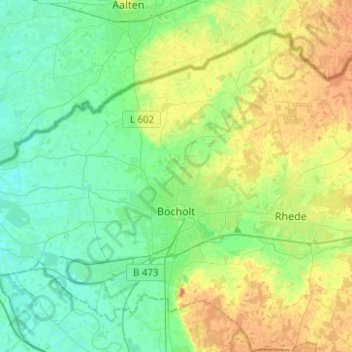
Nome: Mapa topográfico Bocholt, altitude, relevo.
Local: Bocholt, Kreis Borken, North Rhine-Westphalia, Germany (51.78982 6.47251 51.91759 6.72119)
Altitude média: 31 m
Altitude mínima: 16 m
Altitude máxima: 60 m
Outros mapas topográficos
Clique em um mapa para visualizar sua topografia, sua altitude e seu relevo.