
Mapa topográfico Windermere
Clique no mapa para exibir a altitude.
Windermere
There is debate as to whether the stretch of water between Newby Bridge and Lakeside at the southern end of the lake should be considered part of Windermere, or a navigable stretch of the River Leven. This affects the stated length of the lake, which is 11.23 miles (18.07 km) long if measured from the bridge at Newby Bridge,[10] or 10.5 miles (16.9 km) if measured from Lakeside[citation needed]. The lake varies in width up to a maximum of 1 mile (1.6 km), and covers an area of 14.73 km2 (5.69 sq mi).[10] With a maximum depth of 66.7 m (219 ft) and an elevation above sea level of 39 m (128 ft), the lowest point of the lake bed is well below sea level.[10]
Sobre este mapa
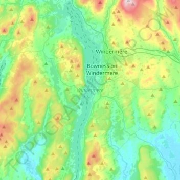
Nome: Mapa topográfico Windermere, altitude, relevo.
Altitude média: 132 m
Altitude mínima: 3 m
Altitude máxima: 478 m
Outros mapas topográficos
Clique em um mapa para visualizar sua topografia, sua altitude e seu relevo.
Storrs
United Kingdom > England > Cumbria > South Lakeland > Bowness-on-Windermere
Altitude média: 93 m