Mapa topográfico Geldern
Mapa interativo
Clique no mapa para exibir a altitude.
Sobre este mapa
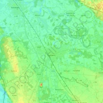
Nome: Mapa topográfico Geldern, altitude, relevo.
Local: Geldern, Kreis Kleve, North Rhine-Westphalia, 47608, Germany (51.46713 6.20062 51.57657 6.42059)
Altitude média: 28 m
Altitude mínima: 16 m
Altitude máxima: 54 m
Geldern lies in the plains of the lower, northern Rhineland, west of the Rhine. Its average elevation is 27 m AMSL. The river Niers, a tributary of the Meuse (Maas), flows through Geldern. The stream Gelderner Fleuth flows into the Niers in Geldern.
Outros mapas topográficos
Clique em um mapa para visualizar sua topografia, sua altitude e seu relevo.
In der Lecht
Germany > North Rhine-Westphalia > Kreis Kleve > Kalkar
In der Lecht, Kalkar, Bedburg-Hau, Kreis Kleve, North Rhine-Westphalia, 47546, Germany
Altitude média: 34 m
Bennenbroek
Germany > North Rhine-Westphalia > Kreis Kleve > Straelen
Bennenbroek, Straelen, Kreis Kleve, North Rhine-Westphalia, 47638, Germany
Altitude média: 24 m
Goch
Germany > North Rhine-Westphalia > Kreis Kleve
Goch, Kreis Kleve, North Rhine-Westphalia, 47574, Germany
Altitude média: 24 m
Uedem
Germany > North Rhine-Westphalia > Kreis Kleve > Uedem
Uedem, Kreis Kleve, North Rhine-Westphalia, 47589, Germany
Altitude média: 31 m
Kalkar
Germany > North Rhine-Westphalia > Kreis Kleve > Kalkar
Kalkar, Kreis Kleve, North Rhine-Westphalia, 47546, Germany
Altitude média: 22 m
Wachtendonk
Germany > North Rhine-Westphalia > Kreis Kleve > Wachtendonk
Wachtendonk, Kreis Kleve, North Rhine-Westphalia, 47669, Germany
Altitude média: 35 m
Jan
Germany > North Rhine-Westphalia > Kreis Kleve > Kranenburg
Jan, Kranenburg, Kreis Kleve, North Rhine-Westphalia, Germany
Altitude média: 27 m
Issum
Germany > North Rhine-Westphalia > Kreis Kleve
Issum, Kreis Kleve, North Rhine-Westphalia, 47661, Germany
Altitude média: 31 m
Emmerich on the Rhine
Germany > North Rhine-Westphalia > Kreis Kleve
Emmerich on the Rhine, Kreis Kleve, North Rhine-Westphalia, 46446, Germany
Altitude média: 18 m