
Mapa topográfico Middletown
Mapa interativo
Clique no mapa para exibir a altitude.
Middletown
Middletown is located at 39°26′58″N 75°42′59″W / 39.44944°N 75.71639°W / 39.44944; -75.71639 (39.4495560, –75.7163207) with an elevation of 66 feet (20.1 m).
Sobre este mapa
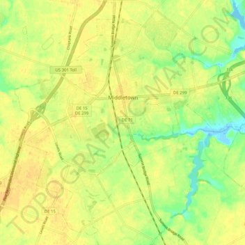
Nome: Mapa topográfico Middletown, altitude, relevo.
Local: Middletown, New Castle County, Delaware, United States (39.40561 -75.76149 39.47761 -75.66007)
Altitude média: 17 m
Altitude mínima: -1 m
Altitude máxima: 25 m
Outros mapas topográficos
Clique em um mapa para visualizar sua topografia, sua altitude e seu relevo.
Wilmington
United States > Delaware > New Castle County > Wilmington
On the western side of Market Street, the Piedmont topography is rocky and hilly, rising to a point that marks the watershed between the Brandywine River and the Christina River. This watershed line runs along Delaware Avenue westward from 10th Street and Market Street.
Altitude média: 43 m
Runnymeade
United States > Delaware > New Castle County > Hockessin, Delaware > Runnymeade
Altitude média: 92 m
Tree Top Valley
United States > Delaware > New Castle County > Hockessin, Delaware > Tree Top Valley
Altitude média: 93 m