
Mapa topográfico Louisville
Mapa interativo
Clique no mapa para exibir a altitude.
Sobre este mapa
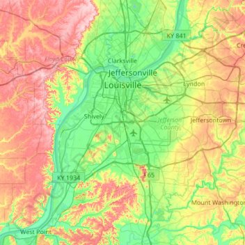
Nome: Mapa topográfico Louisville, altitude, relevo.
Local: Louisville, Jefferson County, Kentucky, United States (37.99710 -85.94706 38.38014 -85.40510)
Altitude média: 188 m
Altitude mínima: 114 m
Altitude máxima: 306 m
Throughout January 1937, 19.17 inches (48.7 cm) of rain fell in Louisville, and by January 27, the Ohio River crested at a record 57.15 feet (17.42 m), almost 30 feet (9.1 m) above flood stage. These events triggered the "Great Flood of 1937", which lasted into early February. The flood submerged 60–70 percent of the city, caused complete loss of power for four days, and forced the evacuation of 175,000 or 230,000 residents, depending on sources. Ninety people died as a result of the flood. It led to dramatic changes in where residents lived. Today, the city is protected by numerous flood walls. After the flood, the areas of high elevation in the eastern part of the city had decades of residential growth.
Outros mapas topográficos
Clique em um mapa para visualizar sua topografia, sua altitude e seu relevo.
Indian Hills Cherokee Section
United States > Kentucky > Jefferson County > Indian Hills
Indian Hills Cherokee Section, Indian Hills, Jefferson County, Kentucky, 40207, United States
Altitude média: 168 m
Louisville
United States > Kentucky > Jefferson County > Louisville
Louisville, Jefferson County, Kentucky, 40202-2923, United States
Altitude média: 180 m
E.P. "Tom" Sawyer State Park
United States > Kentucky > Jefferson County > Louisville > Lakeland
E.P. "Tom" Sawyer State Park, Lakeland, Louisville, Jefferson County, Kentucky, United States
Altitude média: 209 m
Worthington
United States > Kentucky > Jefferson County > Louisville
Worthington, Louisville, Jefferson County, Kentucky, 40241, United States
Altitude média: 208 m
Turkey Run
United States > Kentucky > Jefferson County > Louisville
Turkey Run, Louisville, Jefferson County, Kentucky, United States
Altitude média: 178 m
Prospect
United States > Kentucky > Jefferson County
Prospect, Jefferson County, Kentucky, United States
Altitude média: 166 m
Thornhill
United States > Kentucky > Jefferson County
Thornhill, Jefferson County, Kentucky, United States
Altitude média: 180 m
Forest Hills
United States > Kentucky > Jefferson County > Forest Hills
Forest Hills, Jefferson County, Kentucky, United States
Altitude média: 202 m
Anchorage
United States > Kentucky > Jefferson County > Anchorage
Anchorage, Jefferson County, Kentucky, United States
Altitude média: 219 m
Riverside Gardens
United States > Kentucky > Jefferson County > Louisville
Riverside Gardens, Louisville, Jefferson County, Kentucky, 40216, United States
Altitude média: 136 m
Coldstream
United States > Kentucky > Jefferson County
Coldstream, Jefferson County, Kentucky, United States
Altitude média: 219 m
Saint Dennis
United States > Kentucky > Jefferson County > Louisville
Saint Dennis, Louisville, Jefferson County, Kentucky, 40216, United States
Altitude média: 138 m