
Mapa topográfico Augusta
Mapa interativo
Clique no mapa para exibir a altitude.
Sobre este mapa
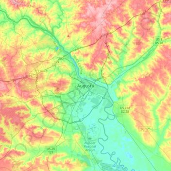
Nome: Mapa topográfico Augusta, altitude, relevo.
Local: Augusta, Richmond County, Georgia, 30901, United States (33.31097 -82.13484 33.63097 -81.81484)
Altitude média: 90 m
Altitude mínima: 25 m
Altitude máxima: 180 m
As with the rest of the state, Augusta has a humid subtropical climate (Köppen Cfa), with short, mild winters, very hot, humid summers, and a wide diurnal temperature variation throughout much of the year, despite its low elevation and moisture. The monthly daily average temperature ranges from 45.4 °F (7.4 °C) in January to 81.6 °F (27.6 °C) in July; there are 53 nights with the low reaching the freezing mark, 82 days reaching or exceeding 90 °F (32 °C), and 5.5 days reaching 100 °F (38 °C) annually. Extreme temperatures range from −1 °F (−18 °C) on January 21, 1985 up to 108 °F (42 °C) on August 10, 2007 and August 21, 1983. Snowfall is not nearly as common as in Atlanta, due largely to Augusta's elevation, with downtown Augusta being about 900 ft (270 m) lower than downtown Atlanta. Freezing rain is also a threat in wintertime.
Outros mapas topográficos
Clique em um mapa para visualizar sua topografia, sua altitude e seu relevo.
Valley Park
United States > Georgia > Augusta > Valley Park
Valley Park, Augusta, Richmond County, Georgia, 30909, United States
Altitude média: 98 m
Spanish Trace
United States > Georgia > Augusta > Spanish Trace
Spanish Trace, Augusta, Richmond County, Georgia, 30815-6609, United States
Altitude média: 113 m