
Mapa topográfico Cockermouth
Mapa interativo
Clique no mapa para exibir a altitude.
Cockermouth
Cockermouth has a temperate climate that is influenced by the Irish Sea and its low-lying elevation. Cockermouth receives slightly below average rainfall compared with the UK average. Temperatures are also round about average compared with other parts of the UK. The nearest weather station for which online records are available is Aspatria, about 7 miles (11 kilometres) north-northeast of the town centre.
Sobre este mapa
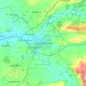
Nome: Mapa topográfico Cockermouth, altitude, relevo.
Altitude média: 105 m
Altitude mínima: 30 m
Altitude máxima: 361 m