
Mapa topográfico Stock Hill
Mapa interativo
Clique no mapa para exibir a altitude.
Sobre este mapa
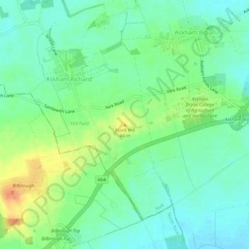
Nome: Mapa topográfico Stock Hill, altitude, relevo.
Altitude média: 28 m
Altitude mínima: 14 m
Altitude máxima: 53 m
Outros mapas topográficos
Clique em um mapa para visualizar sua topografia, sua altitude e seu relevo.
Rawcliffe
United Kingdom > England > York
Rawcliffe, York, Yorkshire and the Humber, England, United Kingdom
Altitude média: 14 m
Airedale
United Kingdom > England > York
Airedale, Wentworth Way, Heslington, York, Yorkshire and the Humber, England, YO10 5NG, United Kingdom
Altitude média: 136 m
Hogg's Pond
United Kingdom > England > York
Hogg's Pond, Chaloners Road, Woodthorpe, York, Yorkshire and the Humber, England, YO24 2TW, United Kingdom
Altitude média: 14 m