
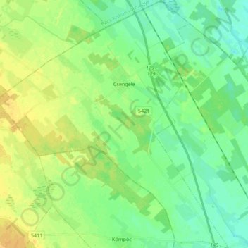
Mapa topográfico Csengele
Mapa interativo
Clique no mapa para exibir a altitude.
Sobre este mapa
Nome: Mapa topográfico Csengele, altitude, relevo.
Altitude média: 95 m
Altitude mínima: 86 m
Altitude máxima: 107 m
Outros mapas topográficos
Clique em um mapa para visualizar sua topografia, sua altitude e seu relevo.
Mindszent
Hungary > Csongrád-Csanád County
Mindszent, Hódmezővásárhelyi járás, Csongrád-Csanád County, Southern Great Plain, Great Plain and North, 6630, Hungary
Altitude média: 80 m
Maros
Hungary > Csongrád-Csanád County > Apátfalva
Maros, Apátfalva, Makói járás, Csongrád-Csanád County, Southern Great Plain, Great Plain and North, 6931, Hungary
Altitude média: 86 m
Forráskút
Hungary > Csongrád-Csanád County > Forráskút
Forráskút, Mórahalmi járás, Csongrád-Csanád County, Southern Great Plain, Great Plain and North, 6793, Hungary
Altitude média: 94 m
Mórahalom
Hungary > Csongrád-Csanád County > Mórahalom
Mórahalom, Mórahalmi járás, Csongrád-Csanád County, Southern Great Plain, Great Plain and North, Hungary
Altitude média: 97 m
Makó
Hungary > Csongrád-Csanád County > Makó > Makó
Makó, Makói járás, Csongrád-Csanád County, Southern Great Plain, Great Plain and North, 6900, Hungary
Altitude média: 83 m
Csongrád
Hungary > Csongrád-Csanád County > Csongrád > Csongrád
Csongrád, Csongrádi járás, Csongrád-Csanád County, Southern Great Plain, Great Plain and North, 6640, Hungary
Altitude média: 82 m
Szeged
Hungary > Csongrád-Csanád County > Szeged
Szeged, Szegedi járás, Csongrád-Csanád County, Southern Great Plain, Great Plain and North, 6700, Hungary
Altitude média: 82 m
Maros
Hungary > Csongrád-Csanád County > Apátfalva
Maros, Apátfalva, Makói járás, Csongrád-Csanád County, Southern Great Plain, Great Plain and North, 6931, Hungary
Altitude média: 86 m
Ópusztaszer
Hungary > Csongrád-Csanád County > Ópusztaszer
Ópusztaszer, Kisteleki járás, Csongrád-Csanád County, Southern Great Plain, Great Plain and North, 6767, Hungary
Altitude média: 83 m