
Mapa topográfico Bhuj
Mapa interativo
Clique no mapa para exibir a altitude.
Sobre este mapa
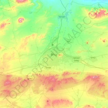
Nome: Mapa topográfico Bhuj, altitude, relevo.
Local: Bhuj, Bhuj Taluka, Kachchh, Gujarat, 370001, India (23.08724 69.50834 23.40724 69.82834)
Altitude média: 130 m
Altitude mínima: 10 m
Altitude máxima: 336 m
Bhuj has an average elevation of 110 metres (360 feet). On the eastern side of the city is a hill known as Bhujia Hill, on which there is a Bhujia Fort, that separates Bhuj city and Madhapar town ( considered one of the richest villages in Asia ). It has two lakes namely Hamirsar and Deshadsar (દેેેશળસર).
Outros mapas topográficos
Clique em um mapa para visualizar sua topografia, sua altitude e seu relevo.
Lakhond
India > Gujarat > Bhuj Taluka > Lakhond
Lakhond, Bhuj Taluka, Kachchh, Gujarat, 370105, India
Altitude média: 109 m