
Mapa topográfico Loughborough
Mapa interativo
Clique no mapa para exibir a altitude.
Sobre este mapa
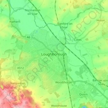
Nome: Mapa topográfico Loughborough, altitude, relevo.
Altitude média: 61 m
Altitude mínima: -10 m
Altitude máxima: 188 m
Outros mapas topográficos
Clique em um mapa para visualizar sua topografia, sua altitude e seu relevo.
Thurmaston
United Kingdom > England > Leicestershire > Charnwood
Thurmaston, Charnwood, Leicestershire, England, United Kingdom
Altitude média: 62 m
Cropston
United Kingdom > England > Leicestershire > Charnwood
Cropston, Charnwood, Leicestershire, England, LE7 7GE, United Kingdom
Altitude média: 83 m
Ulverscroft
United Kingdom > England > Leicestershire > Charnwood
Ulverscroft, Charnwood, Leicestershire, England, United Kingdom
Altitude média: 187 m
Charnwood Water
United Kingdom > England > Leicestershire > Charnwood > Woodthorpe
Charnwood Water, Woodthorpe, Charnwood, Leicestershire, England, United Kingdom
Altitude média: 47 m
Newtown Linford
United Kingdom > England > Leicestershire > Charnwood
Newtown Linford, Charnwood, Leicestershire, England, United Kingdom
Altitude média: 115 m
South Croxton
United Kingdom > England > Leicestershire > Charnwood
South Croxton, Charnwood, Leicestershire, England, LE7 3RL, United Kingdom
Altitude média: 110 m
Lea Wood
United Kingdom > England > Leicestershire > Charnwood > Newtown Linford
Lea Wood, Ulverscroft, Newtown Linford, Charnwood, Leicestershire, England, United Kingdom
Altitude média: 170 m
Conservation Area
United Kingdom > England > Leicestershire > Charnwood
Conservation Area, Pig Path, Beacon Cottage Farm, Woodhouse, Charnwood, Leicestershire, England, LE12 8TE, United Kingdom
Altitude média: 168 m
Moat Hill Spinney
United Kingdom > England > Leicestershire > Charnwood > Cotes
Moat Hill Spinney, Cotes, Charnwood, Leicestershire, England, United Kingdom
Altitude média: 50 m
Woodhouse
United Kingdom > England > Leicestershire > Charnwood
Woodhouse, Charnwood, Leicestershire, England, LE12 8UF, United Kingdom
Altitude média: 78 m
Mountsorrel
United Kingdom > England > Leicestershire > Charnwood
Mountsorrel, Charnwood, Leicestershire, England, United Kingdom
Altitude média: 57 m
Bradgate Park
United Kingdom > England > Leicestershire > Charnwood > Newtown Linford
Bradgate Park, Newtown Linford, Charnwood, Leicestershire, England, LE6 0HE, United Kingdom
Altitude média: 126 m
Birstall
United Kingdom > England > Leicestershire > Charnwood
Birstall, Charnwood, Leicestershire, England, United Kingdom
Altitude média: 64 m
Quorn
United Kingdom > England > Leicestershire > Charnwood
Quorn, Charnwood, Leicestershire, England, LE12 8DS, United Kingdom
Altitude média: 55 m
Shepshed
United Kingdom > England > Leicestershire > Charnwood
Shepshed, Charnwood, Leicestershire, England, United Kingdom
Altitude média: 111 m
Wymeswold
United Kingdom > England > Leicestershire > Charnwood
Wymeswold, Charnwood, Leicestershire, England, United Kingdom
Altitude média: 87 m
Beacon Hill Country Park
United Kingdom > England > Leicestershire > Charnwood > Woodhouse Eaves
Beacon Hill Country Park, Woodhouse, Woodhouse Eaves, Charnwood, Leicestershire, England, LE12 8TA, United Kingdom
Altitude média: 163 m
Rothley
United Kingdom > England > Leicestershire > Charnwood
Rothley, Charnwood, Leicestershire, England, United Kingdom
Altitude média: 64 m
Top Town Plantation
United Kingdom > England > Leicestershire > Charnwood > Walton on the Wolds
Top Town Plantation, Walton on the Wolds, Charnwood, Leicestershire, East Midlands, England, United Kingdom
Altitude média: 85 m
Stanford Park
United Kingdom > England > Leicestershire > Charnwood > Hoton
Stanford Park, Hoton, Charnwood, Leicestershire, East Midlands, England, LE12 5QW, United Kingdom
Altitude média: 69 m
Barrow upon Soar
United Kingdom > England > Leicestershire > Charnwood
Barrow upon Soar, Charnwood, Leicestershire, England, United Kingdom
Altitude média: 62 m
Woodhouse Eaves
United Kingdom > England > Leicestershire > Charnwood
Woodhouse Eaves, Charnwood, Leicestershire, England, LE12 8SF, United Kingdom
Altitude média: 117 m
Woodthorpe
United Kingdom > England > Leicestershire > Charnwood
Woodthorpe, Charnwood, Leicestershire, England, LE12 8UG, United Kingdom
Altitude média: 56 m
Sileby
United Kingdom > England > Leicestershire > Charnwood
Sileby, Charnwood, Leicestershire, England, United Kingdom
Altitude média: 69 m
Beeby
United Kingdom > England > Leicestershire > Charnwood
Beeby, Charnwood, Leicestershire, England, United Kingdom
Altitude média: 101 m
Nanpantan
United Kingdom > England > Leicestershire > Charnwood
Nanpantan, Charnwood, Leicestershire, England, LE11 3YQ, United Kingdom
Altitude média: 101 m
East Goscote
United Kingdom > England > Leicestershire > Charnwood
East Goscote, Borough of Charnwood, Leicestershire, England, LE7 3ZU, United Kingdom
Altitude média: 65 m
Walton on the Wolds
United Kingdom > England > Leicestershire > Charnwood
Walton on the Wolds, Charnwood, Leicestershire, England, LE12 8JE, United Kingdom
Altitude média: 78 m
Syston
United Kingdom > England > Leicestershire > Charnwood
Syston, Charnwood, Leicestershire, England, United Kingdom
Altitude média: 57 m
Cossington
United Kingdom > England > Leicestershire > Charnwood
Cossington, Charnwood, Leicestershire, England, United Kingdom
Altitude média: 65 m
Swithland
United Kingdom > England > Leicestershire > Charnwood
Swithland, Charnwood, Leicestershire, England, United Kingdom
Altitude média: 74 m