
Mapa topográfico Shrewsbury
Mapa interativo
Clique no mapa para exibir a altitude.
Shrewsbury
Shrewsbury is about 14 miles (23 km) west of Telford, 43 miles (69 km) west of Birmingham and the West Midlands Conurbation, and about 153 miles (246 km) north-west of the capital, London. More locally, the town is to the east of Welshpool, with Bridgnorth and Kidderminster to the south-east. The border with Wales is 9 miles (14 km) to the west. The town centre is partially built on a hill whose elevation is, at its highest, 246 feet (75 m) above sea level. The longest river in the UK, the River Severn, flows through the town, forming a meander around its centre. The town is subject to flooding from the river.
Sobre este mapa
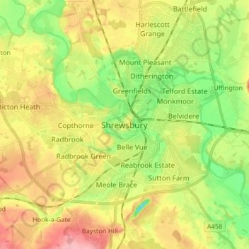
Nome: Mapa topográfico Shrewsbury, altitude, relevo.
Altitude média: 71 m
Altitude mínima: 19 m
Altitude máxima: 131 m