
Mapa topográfico St Albans
Mapa interativo
Clique no mapa para exibir a altitude.
Sobre este mapa
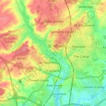
Nome: Mapa topográfico St Albans, altitude, relevo.
Altitude média: 100 m
Altitude mínima: 64 m
Altitude máxima: 141 m
St Albans was an ancient borough created following the dissolution of the monastery in 1539. It consisted of the ancient parish of St Albans (also known as the Abbey parish) and parts of St Michael and St Peter. The municipal corporation was reformed by the Municipal Corporations Act 1835 and the boundary was adjusted to additionally include part of the parish of St Stephen. In 1887 the borough gained city status, following the elevation of St Albans Abbey to cathedral, and the boundary was adjusted to include part of the parish of Sandridge.
Outros mapas topográficos
Clique em um mapa para visualizar sua topografia, sua altitude e seu relevo.
Bricket Wood
United Kingdom > England > Hertfordshire > St Albans
Bricket Wood, St Albans, Hertfordshire, England, AL2 3QS, United Kingdom
Altitude média: 82 m
Highfield Park
United Kingdom > England > Hertfordshire > St Albans > Colney Heath
Highfield Park, Colney Heath, St Albans, Hertfordshire, England, United Kingdom
Altitude média: 87 m
Amwell
United Kingdom > England > Hertfordshire > St Albans > Wheathampstead
Amwell, Wheathampstead, St Albans, Hertfordshire, England, AL4 8EB, United Kingdom
Altitude média: 106 m
Blackmore End
United Kingdom > England > Hertfordshire > St Albans > Wheathampstead
Blackmore End, Wheathampstead, St Albans, Hertfordshire, England, AL4 8LX, United Kingdom
Altitude média: 114 m
Nomansland
United Kingdom > England > Hertfordshire > St Albans > Sandridge
Nomansland, Sandridge, St Albans, Hertfordshire, England, AL4 8EL, United Kingdom
Altitude média: 105 m
Harpenden
United Kingdom > England > Hertfordshire > St Albans
Harpenden, St Albans, Hertfordshire, England, United Kingdom
Altitude média: 119 m
Chiswell Green
United Kingdom > England > Hertfordshire > St Albans
Chiswell Green, St Albans, Hertfordshire, England, AL2 3DA, United Kingdom
Altitude média: 94 m
Napsbury Park
United Kingdom > England > Hertfordshire > St Albans > London Colney
Napsbury Park, London Colney, St Albans, Hertfordshire, England, AL2 1GF, United Kingdom
Altitude média: 78 m
Colney Heath
United Kingdom > England > Hertfordshire > St Albans
Colney Heath, St Albans, Hertfordshire, England, United Kingdom
Altitude média: 81 m
River Ver
United Kingdom > England > Hertfordshire > St Albans
River Ver, St Albans, Hertfordshire, England, United Kingdom
Altitude média: 115 m
Wheathampstead
United Kingdom > England > Hertfordshire > St Albans
Wheathampstead, St Albans, Hertfordshire, England, United Kingdom
Altitude média: 109 m
London Colney
United Kingdom > England > Hertfordshire > St Albans
London Colney, St Albans, Hertfordshire, England, United Kingdom
Altitude média: 75 m
Redbourn
United Kingdom > England > Hertfordshire > St Albans
Redbourn, St Albans, Hertfordshire, England, United Kingdom
Altitude média: 121 m
Verulamium Lake
United Kingdom > England > Hertfordshire > St Albans
Verulamium Lake, St Stephens, St Albans, Hertfordshire, East of England, England, United Kingdom
Altitude média: 102 m
Sandridge
United Kingdom > England > Hertfordshire > St Albans
Sandridge, St Albans, Hertfordshire, England, United Kingdom
Altitude média: 105 m