
Obrigado por apoiar este site ❤️
Faça uma doação
Faça uma doação
Mapa topográfico Ciudad Satélite
Clique no mapa para exibir a altitude.
Obrigado por apoiar este site ❤️
Faça uma doação
Faça uma doação
Sobre este mapa
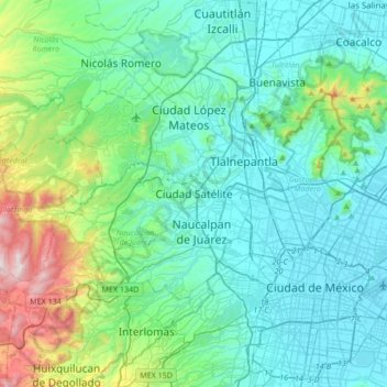
Nome: Mapa topográfico Ciudad Satélite, altitude, relevo.
Altitude média: 2.451 m
Altitude mínima: 2.223 m
Altitude máxima: 3.509 m
Obrigado por apoiar este site ❤️
Faça uma doação
Faça uma doação
Outros mapas topográficos
Clique em um mapa para visualizar sua topografia, sua altitude e seu relevo.
Naucalpan de Juárez
The highest peaks are the Organo and La Malinche mountains at 3,650 metres (11,980 feet) above sea level. Other notable elevations include la Cantera, El Cedral, San Joselito, La Plantación and Peña del Rayo. The main rivers through the area include the Totolina, San Lorenzo and Los Remedios. Water supply…
Altitude média: 2.366 m