
Faça uma doação
Mapa topográfico Falcón
Clique no mapa para exibir a altitude.
Faça uma doação
Sobre este mapa
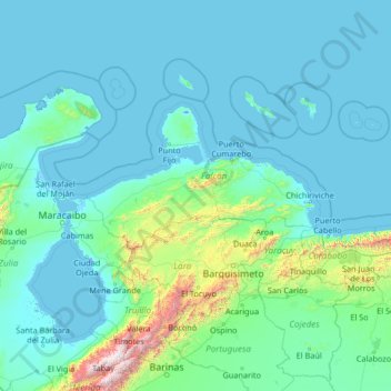
Nome: Mapa topográfico Falcón, altitude, relevo.
Local: Falcón, Región Centroccidental, Venezuela (8.40000 -72.43333 13.60000 -67.23333)
Altitude média: 209 m
Altitude mínima: -5 m
Altitude máxima: 4.623 m
Faça uma doação
Outros mapas topográficos
Clique em um mapa para visualizar sua topografia, sua altitude e seu relevo.
Falcon State
Falcón State is located in the north of the Corian System. To the south, Falcón contains medium-altitude mountain ranges configured from east to west, which in the eastern part of the state reach the Caribbean Sea, forming maritime valleys.
Altitude média: 221 m
Faça uma doação
Anzoategui State
The vegetation of the Anzoátegui State is typical temperate. It is largely determined by altitude, climate and season of the year, where areas of snow-covered scrub, cujíes and small southern species alternate. It also has a tree called caderoms, this includes resistant or environmentally adapted varieties.
Altitude média: 156 m
Miranda State
The hydrography of Miranda State is characterized by the short course and low flow of its rivers, with the exception of Tuy. This characteristic, combined with the settlement of the largest mass of population in the country, gives its rivers great significance as sources of water for urban consumption. The Tuy…
Altitude média: 255 m
Faça uma doação
Faça uma doação
Faça uma doação