Mapa topográfico Columbus
Mapa interativo
Clique no mapa para exibir a altitude.
Sobre este mapa
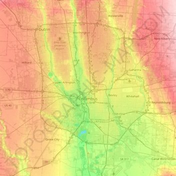
Nome: Mapa topográfico Columbus, altitude, relevo.
Local: Columbus, Franklin County, Ohio, United States (39.80869 -83.21018 40.15731 -82.77131)
Altitude média: 261 m
Altitude mínima: 169 m
Altitude máxima: 343 m
The confluence of the Scioto and Olentangy rivers is just northwest of Downtown Columbus. Several smaller tributaries course through the Columbus metropolitan area, including Alum Creek, Big Walnut Creek and Darby Creek. Columbus is considered to have relatively flat topography thanks to a large glacier that covered most of Ohio during the Wisconsin Ice Age. However, there are sizable differences in elevation through the area, with the high point of Franklin County being 1,132 ft (345 m) above sea level near New Albany, and the low point being 670 ft (200 m) where the Scioto River leaves the county near Lockbourne. Numerous ravines near the rivers and creeks also add variety to the landscape. Tributaries to Alum Creek and the Olentangy River cut through shale, while tributaries to the Scioto River cut through limestone.
Outros mapas topográficos
Clique em um mapa para visualizar sua topografia, sua altitude e seu relevo.
Worthington
United States > Ohio > Franklin County
Worthington, Sharon Township, Franklin County, Ohio, 43085, United States
Altitude média: 262 m
Grandview Heights
United States > Ohio > Franklin County
Grandview Heights, Franklin County, Ohio, United States
Altitude média: 232 m
Shepard
United States > Ohio > Franklin County > Columbus
Shepard, Columbus, Franklin County, Ohio, 43129, United States
Altitude média: 245 m
Madison Township
United States > Ohio > Franklin County
Madison Township, Franklin County, Ohio, United States
Altitude média: 232 m
Dublin
United States > Ohio > Franklin County
Dublin, Washington Township, Franklin County, Ohio, United States
Altitude média: 275 m
Columbus
United States > Ohio > Franklin County > Columbus
Columbus, Franklin County, Ohio, 43216, United States
Altitude média: 255 m
Riverlea
United States > Ohio > Franklin County > Riverlea
Riverlea, Sharon Township, Franklin County, Ohio, United States
Altitude média: 247 m
Bexley
United States > Ohio > Franklin County > Bexley > Bexley
Bexley, Franklin County, Ohio, 43209, United States
Altitude média: 243 m
Franklin County
United States > Ohio > Franklin County
Franklin County, Ohio, United States
Altitude média: 262 m
Galloway
United States > Ohio > Franklin County
Galloway, Prairie Township, Franklin County, Ohio, 43119, United States
Altitude média: 276 m
Bexley
United States > Ohio > Franklin County
Bexley, Franklin County, Ohio, 43209, United States
Altitude média: 240 m