
Mapa topográfico Albacete
Mapa interativo
Clique no mapa para exibir a altitude.
Sobre este mapa
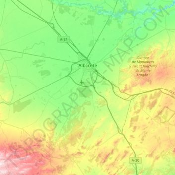
Nome: Mapa topográfico Albacete, altitude, relevo.
Local: Albacete, Castela-Mancha, Espanha (38.67218 -2.18039 39.18626 -1.62279)
Altitude média: 786 m
Altitude mínima: 560 m
Altitude máxima: 1.341 m
Outros mapas topográficos
Clique em um mapa para visualizar sua topografia, sua altitude e seu relevo.
Huerta del Mocho
Espanha > Castela-Mancha > Valle de Alcudia > Almodóvar del Campo
Altitude média: 805 m
Rio Guadiana
Espanha > Castela-Mancha > La Mancha > Daimiel
O rio Guadiana é um rio da Península Ibérica que nasce a uma altitude de cerca de 1 700 m, nas lagoas de Ruidera, na província espanhola de Cidade Real, renasce nos Ojos del Guadiana e desagua no oceano Atlântico (mais precisamente no golfo de Cádis), entre a cidade portuguesa de Vila Real de Santo…
Altitude média: 616 m