
Faça uma doação
Mapa topográfico Nuptse I
Clique no mapa para exibir a altitude.
Faça uma doação
Nuptse I
Nuptse or Nubtse is a mountain in the Khumbu region of the Mahalangur Himal, a part of the Nepalese Himalayas. It lies 2 km (1.2 mi) to the southwest of Mount Everest. The main peak, Nuptse I with an elevation of 7,861 m (25,791 ft), was first climbed on May 16, 1961 by Dennis Davis and Sherpa Tashi. After a hiatus of almost 20 years, Nuptse became an objective of mountaineers again, with important routes being put up on its west, south, and north faces.
Faça uma doação
Sobre este mapa
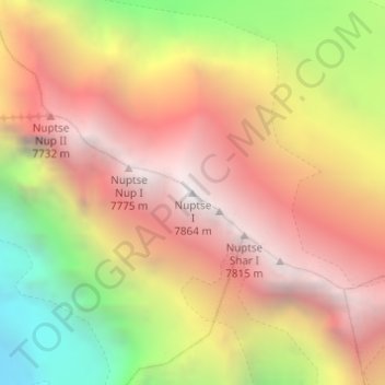
Nome: Mapa topográfico Nuptse I, altitude, relevo.
Local: Nuptse I, Khumbupasanglahmu, Solukhumbu, Koshi Province, Nepal (27.96732 86.88691 27.96742 86.88701)
Altitude média: 6.833 m
Altitude mínima: 5.456 m
Altitude máxima: 7.832 m
Faça uma doação
Outros mapas topográficos
Clique em um mapa para visualizar sua topografia, sua altitude e seu relevo.